Planning of Red River banks enriches Hanoi’s green spaces
The planning is designed to form a region integrating parks and green space with overall infrastructure, cultural sites, and socio-economic activities.
A planning of Red River riparian areas in Hanoi is expected to enrich the city’s green spaces with the presence of parks, cultural and recreation zones for the country’s second-most populous city.
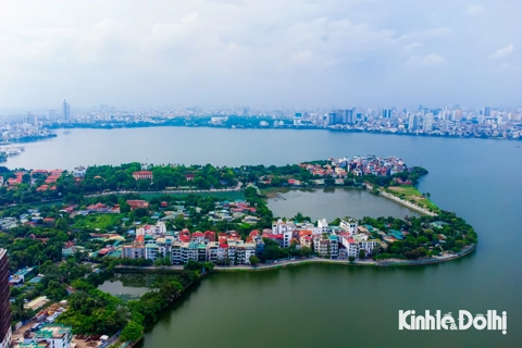
| Overview of Red River in Hanoi. Photo: Tran Dung/Kinhtedothi |
The planning is scheduled to be completed in June after a decade being left stalled.
It is designed to cover an area of 11,000 ha, along a section of 40 km on Red River which originates from China. The planned region embraces 13 districts with a population of roughly 320,000 people.
Duong Duc Tuan, deputy chairman of the Hanoi People’s Committee, said at a meeting on March 10 that 30% of the planning is alluvial islands and one fifth of the total area is for urban development.
The city will insist banning high-rise buildings in the riparian areas along the river, in the north and the south, he added.
Dao Ngoc Nghiem, architect and former director of the Hanoi Department of Planning and Architecture, said the region is home to traditional handicraft villages like Bat Trang, Van Khe, Tu Lien, Yen Phu, and Phuc Xa, and more than 100 historic heritage sites.
It integrates parks and green space with overall land use, infrastructure, cultural sites, and socio-economic activities.
Secretary of the Hanoi Party Committee Vuong Dinh Hue said the planning, once being executed, will help improve livelihood for millions of people living on the river banks. It’s the long-lasting bottleneck that the local authority wants to tackle, he said at a meeting on March 11.
The planning will boost Hanoi’s capacity against flooding and improve locals’ living standards, as well as facilitate Hanoi’s tourism and waterway transport that help ease burden on urban traffic, he said.
Planning of Red River banks in Hanoi have been initiated nearly three decades ago. In mid-2000s, the Hanoi’s authorities used to cooperate with the Seoul government of South Korea for the planning.
In The Comprehensive Urban Development Programme in Hanoi Capital City (HAIDEP) in 2006 – 2007 with the support by the Japan International Cooperation Agency (JICA), consultants argued that a master plan is crucial to rein in a runaway development. It will serve not merely as a pointer of spatial development but as a guide with its system comprising a vision and goals, strategies, sector plans including projects and actions, as well as implementation and monitoring mechanisms supported with the necessary institutional setups.
HAIDEP stressed the importance of Hanoi’s landscape, saying that Hanoi’s landscape is an important aspect in urban planning and development for both experts. The landscape in Hanoi has ample opportunities for improvement, something which is very much critical to establishing an identifiable image.
For this, the landscape must be dealt with not only from the aesthetic viewpoint but more specifically in the context of urban design which integrates the physical, socio-economic, and aesthetic aspects and translates them into feasible actions.
The Red River, which originates from China’s Yunnan Province, descends 1,149 km through Vietnam to exit into the Gulf of Tonkin. The river flows through 18 cities and provinces in Vietnam, including Hanoi.