Social Affairs
Typhoon Mun to hit Vietnam on July 4
Currently, typhoon Mun is going faster (15 km/h) to the west-northwest.
The tropical storm in the South China Sea, known as the East Sea in Vietnam, named Typhoon Mun, the second arising in the sea, is forecast to make landfall in Vietnam’s northern provinces on early July 4, according to the National Center for Hydro-Meteorological Forecasting (NCHMF).
It is predicted that Mun will move northwest at the speed of 15km per hour, with a constant intensity, traversing Hainan Island this afternoon, entering the Beibu Gulf, and leaning towards northern Vietnam.
From July 3 to 4, winds of scale 6-7 (39-49 km/h to 50-61km/h according to Vietnam's scale) will shroud most portions of the South China Sea, heavy rain will pound central-western Hainan Island and northern provinces of Vietnam, the NCHMF said.
Currently, Typhoon Mun is going faster (15 km/h) to the west-northwest. At 7:00 am today, the storm center was about 220 km from Bach Long Vi island, about 340 km from the mainland of Quang Ninh - Nam Dinh province to the southeast, the strongest wind is 75 km/hour (level 8).
The NCHMF stated that at 7:00 am on July 4, the storm center is right on the coast of the provinces from Quang Ninh to Ninh Binh with constant winds.
In the Gulf of Tonkin (including the districts of Bach Long Vi, Co To, Cat Hai and Van Don) from the night of July 3, the wind gradually increase to level 7-8, the center noted.
In the next 24 hours, the storm is forecast to move west-northwest at a speed of about 10-15km per hour.
The typhoon will cause heavy rain from Thanh Hoa province to Da Nang city, some mountainous provinces like Hoa Binh and Son La. Heavy rain is expected to occur in Hanoi on the night of July 3.
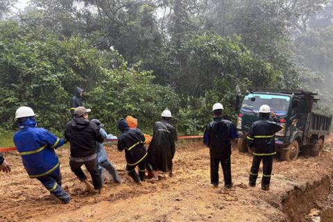
Northern provinces make prompt preparations for coming typhoon
Nguyen Xuan Cuong, deputy head of the Central Steering Committee for Disaster Prevention, has asked localities from Quang Ninh to Ninh Binh to prepare for typhoon Mun. Local authorities are requested to guide vessels to take refuge in safe shelters and keep in touch with the mainland, while calling ships operating at sea to return.
He stressed the need to ensure safety for 1,640 tourists stuck on Co To island of Quang Ninh and inform them of the storm’s developments.
Localities should pay special attention to safety of dykes, especially in Thai Binh province, while keeping a close watch on reservoirs and hydropower plants, Cuong asked.
The northern province of Quang Ninh has temporary banned tourist and passenger vessels from sailing to the islands from 11:00 am on July 3.
According to the Quang Ninh inland water port authority, vessels were banned to travel to Co To island from 6:00 am the same day. The agency has requested vessels to move to safe shelters in Ha Long Bay, Cam Pha, Dam Ha and Mong Cai areas.
It is predicted that Mun will move northwest at the speed of 15km per hour, with a constant intensity, traversing Hainan Island this afternoon, entering the Beibu Gulf, and leaning towards northern Vietnam.
From July 3 to 4, winds of scale 6-7 (39-49 km/h to 50-61km/h according to Vietnam's scale) will shroud most portions of the South China Sea, heavy rain will pound central-western Hainan Island and northern provinces of Vietnam, the NCHMF said.

Location of Typhoon Mun's path. Source: NCHMF
|
The NCHMF stated that at 7:00 am on July 4, the storm center is right on the coast of the provinces from Quang Ninh to Ninh Binh with constant winds.
In the Gulf of Tonkin (including the districts of Bach Long Vi, Co To, Cat Hai and Van Don) from the night of July 3, the wind gradually increase to level 7-8, the center noted.
In the next 24 hours, the storm is forecast to move west-northwest at a speed of about 10-15km per hour.
The typhoon will cause heavy rain from Thanh Hoa province to Da Nang city, some mountainous provinces like Hoa Binh and Son La. Heavy rain is expected to occur in Hanoi on the night of July 3.
Northern provinces make prompt preparations for coming typhoon
Nguyen Xuan Cuong, deputy head of the Central Steering Committee for Disaster Prevention, has asked localities from Quang Ninh to Ninh Binh to prepare for typhoon Mun. Local authorities are requested to guide vessels to take refuge in safe shelters and keep in touch with the mainland, while calling ships operating at sea to return.
He stressed the need to ensure safety for 1,640 tourists stuck on Co To island of Quang Ninh and inform them of the storm’s developments.
Localities should pay special attention to safety of dykes, especially in Thai Binh province, while keeping a close watch on reservoirs and hydropower plants, Cuong asked.
The northern province of Quang Ninh has temporary banned tourist and passenger vessels from sailing to the islands from 11:00 am on July 3.
According to the Quang Ninh inland water port authority, vessels were banned to travel to Co To island from 6:00 am the same day. The agency has requested vessels to move to safe shelters in Ha Long Bay, Cam Pha, Dam Ha and Mong Cai areas.