Green corridor as solution for Hanoi’s sustainable urban development
Hanoi needs green corridors to keep urban development under control and ensure sustainable growth.
Rapid urbanization and uncontrollable population growth have led to unprecedented urban development in Hanoi, so experts suggested the need to establish green corridors to ensure sustainable expansion.
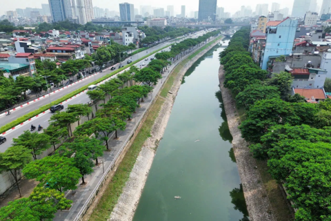
| Lines of green trees alongside construction project in Cau Giay District. Photo: Pham Hung |
For years, Hanoi has focused on urban development that has not been consistent with construction planning. This, in turn, has led to a concentration of infrastructure development in downtown areas or "prime locations" and subsequently to unbalanced investment among the city's localities.
Before 2010, as rumors spread about creating a national administrative center in western Hanoi, investors rushed to build a series of urban residential areas in districts of Bac Tu Liem, Quoc Oai, Hoai Duc, and Thach That. But to date, only some in Bac Tu Liem have seen people move in, while others have gradually turned into "ghost towns."
Hanoi has announced major infrastructure projects in the past three years, including expressways and bridges crossing the Red River. This again led to a land frenzy in the East of Hanoi, especially in Dong Anh, Gia Lam, and Long Bien districts.
Former director of Hanoi's Department of Planning and Architect Dao Ngoc Nghiem said the infrastructure overload with hundreds of apartment buildings and residential areas in western Hanoi highlights the lack of long-term vision in urban development.
"This process, if not properly managed, would lead to overpopulation in certain areas and result in traffic congestion, flooding, or the lack of green space. In the end, the development process in the city would remain unbalanced and distorted," Nghiem told The Hanoi Times.
Meanwhile, Architect Vu Hoai Duc, lecturer at the Hanoi National University, said urbanization consumed a large agricultural land area.
Duc noted during the 2000-2007 period, agricultural lands in Hanoi shrank from over 40,000 hectares to 37,000 hectares, while urban lands expanded from around 4,000 hectares to over 17,000.
"A decline in the area of green space, water surface, and agricultural lands have caused negative impacts on Hanoi's living environment and urban landscape," Duc told The Hanoi Times.
A necessity for green corridors
According to Vice General Secretary of the Vietnam Urban Planning and Development Association (VUPDA) Truong Van Quang, the Government's Decision No.1259 released ten years ago on the approval of the general planning on construction of Hanoi to 2030, with a vision to 2050 has envisioned the development of Hanoi as a model of the green urban cluster. The capital city would include the metropolitan area and five satellite towns (Soc Son, Son Tay, Hoa Lac, Xuan Mai, Phu Xuyen) interconnected by transport systems of ring roads and centripetal axes linking with national and regional transportation networks.
In a city with an area of over 3,300 square kilometers like Hanoi, the planning reserved only 30% of the land for urban development and 70% for a network of green space running around Red River, Day River, and Nhue River.
With such a structure, Hanoi is expected to have suitable conditions for development while keeping a balance between preserving natural resources and urban growth.
Ten years later, the development of five satellite towns has left much to be desired compared to the rapid growth of the downtown areas.
"It is clear that the strategy of encouraging people to move into satellite towns has not been effective, while the oil-slick-like urban development is threatening the city's green corridor strategy," Quang told The Hanoi Times.
Director of Hanoi's Department of Planning and Architecture Nguyen Truc Anh said the green corridor surrounding the Nhue River is estimated to be 4,500 hectares.
This is seen as a green transitioning space between the downtown and newly urbanized areas, setting a "boundary" for the city's downtown.
"In green corridors, there will be mainly green trees with large parks," he added.
But in fact, Anh said Hanoi, ten years since it was promulgated, the green corridor planning in Decision No.1259 had not been realized with a substantial lack of green parks.
"Hanoi should consider keeping lands for green development rather than for urban projects or risk losing green corridors," Anh said.
“In some countries, the green corridor is seen as a policy and instrument to ensure urban development stays under control and protect the rural areas where the urbanization process may cause negative impacts. Critical factors for a green corridor would be transparency and publicity of strategy for infrastructure and land development within the area,” said Vice General Secretary of the Vietnam Urban Planning and Development Association (VUPDA) Truong Van Quang. |