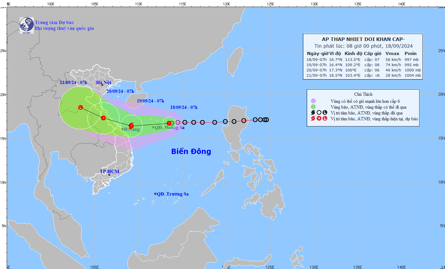
According to the National Center for Hydro-Meteorological Forecasting (NCHMF), a tropical depression is currently producing wind gusts up to force 9 and moving rapidly at about 25 km/h.
It is forecast to strengthen into a storm within the next 24 hours and move toward the Vietnamese mainland between Quang Binh province and the central coastal city of Danang.
The NCHMF reported that the eye of the tropical depression was located about 250 km east of Vietnam's Hoang Sa (Paracel) archipelago at 4:00 a.m. on September 18.
The projected path of the tropical depression. Photo: NCHMF |
It is forecast that within the next 24 hours, around 4 AM on September 19, the tropical depression will change direction and move west-southwest, slowing to a speed of 15-20 km per hour. It will strengthen into a tropical storm (Storm No. 4) about 340 km east-southeast of Vietnam's coastal provinces.
At about 4 AM on September 20, Storm No. 4 will be moving west-northwest at a speed of about 15 km/h. The strongest winds near the center of the storm will remain at force 8, with gusts up to force 10.
Over the next 48 to 72 hours, the storm is expected to change direction and move west-northwest at 10-15 km/h, weakening to a tropical depression over central Laos.
Since this morning, the northeastern area of the East Sea has been experiencing showers and strong thunderstorms, with strong winds gusting up to 75 to 88 km/h and rough seas. The tropical depression also caused waves of two to four meters in the northeastern area of the East Sea.
Vietnam is bracing for more flooding as a tropical depression heads for its central coast, days after Typhoon Yagi unleashed floods and landslides that killed more than 290 people in the north.
The Vietnamese government has warned coastal provinces that the depression is developing in a complicated manner, with possible changes in track, speed, and strength. It would cause heavy rains in central Vietnam.
Authorities in Quang Nam and Danang, home to the tourist town of Hoi An, have been alerting ships at sea to the approaching low pressure system and have search and rescue plans in place.
Assessing natural disasters from now until the end of 2024, the NCHMF said that from now until the end of September, the East Sea is likely to see one or two more storms, probably concentrated in the last ten days of this month, potentially affecting the northern and north-central regions. There will be a high risk of heavy rains and flooding in the central region during the October-November flood season this year.


