Vietnam braces for new strong storm Molave
Molave, the ninth storm to hit Vietnam this year, was about 650 km northeast of Song Tu Tay island at 8:00 am this morning, packing winds of 115-135 kph.
While still struggling to recover from the heavy damages caused by the current historic flooding, locals in central Vietnam are bracing themselves against the looming storm Molave which entered the East Sea early this morning, Kinh te & Do thi reported.
In response, Prime Minister Nguyen Xuan Phuc chaired an urgent online meeting on October 26 to devise plans to mitigate the impact of the storm.
PM Nguyen Xuan Phuc said top priority is given to the evacuation of people from low-lying and flood-prone areas.
In anticipation of “subsequent rainfalls and floods” in central Vietnam, PM Phuc requested that localities keep a close watch on the developments of Molave and make the best preparations possible.
The PM also expressed concerns about the possible recurrence of flash-floods and landslides which claimed the lives of 130 people over the past three weeks.
Mr. Phuc requested local authorities to cancel meetings in the coming days, except urgent ones, to focus their efforts on preventing Molave.
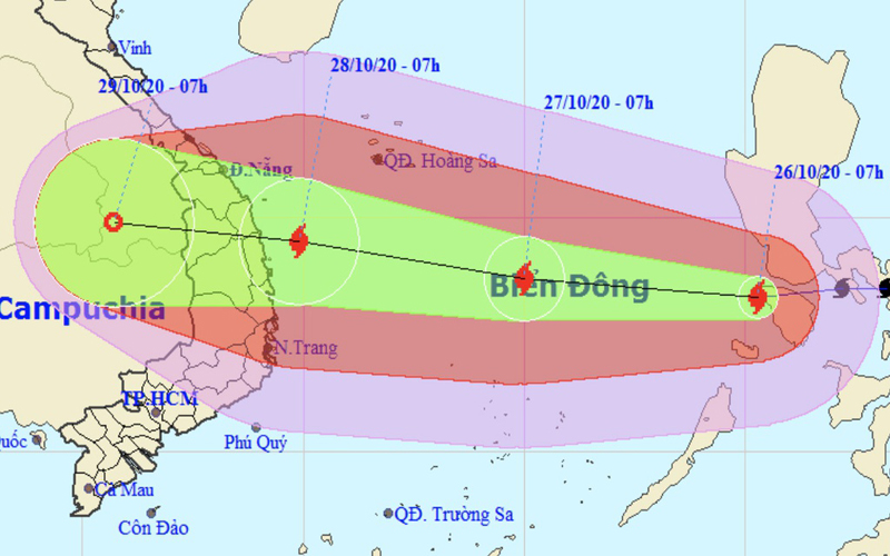
Location and movement of typhoon Molave. Photo: NCHMF |
For his part, Mai Van Khiem, director of the National Centre of Hydro-meteorological and Forecasting (NCHMF), noted that this is a powerful storm, which may cause the waves of between 8-10 meters, and between 5-7 meters when nearing the coast.
The storm is anticipated to bring about roughly 200mm to 350mm of heavy rain in north and north-central provinces from October 27 to October 29, Mr. Khiem said.
He warned central provinces stretching from Nghe An to Quang Binh about the prospect of 500-700mm of rain, in addition to possible flashfloods and landslides in mountainous areas.
With storm Molave set to make landfall in central Vietnam in the next few days, Vietnamese authorities are preparing to relocate 1.2 million coast residents to safer areas.
Molave, the ninth storm to hit Vietnam this year, was about 650 km northeast of Song Tu Tay island at 8:00 am this morning, packing winds of 115-135 kph. The storm is moving fast westward at a speed of 20-25 kph and continues to grow stronger, according to the NCHMF.
Molave would be the most intense storm of 2020 on record and is expected to trigger prolonged flood and an extreme rainfall of 500 mm for many days in central Vietnam, and sink vessels.
Over the next 24 hours, it will move west at 20-25 kph and gradually intensify, with winds of up to 150 kph.
Mr. Khiem said that the storm would reach Vietnamese sea on October 28 morning, before making landfall in the coming hours.
On Wednesday morning, the storm's center would be around 200 km from the coast of Quang Ngai to Binh Dinh with a maximum wind speed of 135 kph, causing waves of up to 10m.
Storm circulation combined with a cold spell would cause heavy rains on a large scale, and localities stretching over 1,000 km from Nghe An to Phu Yen will be battered by torrential downpours and strong winds from Tuesday until Thursday, with rainfall of between 200-400 mm.
Nghe An, Ha Tinh and Quang Binh are told to brace for prolonged downpours until Saturday with total rainfall of up to 700mm. Rainfall of 180mm a day is considered heavy. Mountainous areas will be at high risk of landslides.


