Vietnam evacuates some 250,000 residents as storm Kompasu nears
Storm Kompasu is the eighth one to enter Vietnam's waters so far this year, which will move very fast and directly affect north-central region of Vietnam.
Vietnam’s central coastal provinces have made plans to evacuate 65,000 families with some 250,000 residents from flood-prone areas as storm Kompasu threatens is forecast to make landfall on October 14, according to the National Steering Committee for Natural Disaster Prevention and Control.
The information was unveiled at an online meeting on October 13 between the National Steering Committee for Natural Disaster Prevention and Control and relevant ministries, sectors, and coastal provinces from Thanh Hoa to Quang Binh.
Pham Duc Luan, deputy head of the National Steering Committee for Natural Disaster Prevention and Control said that local authorities have directed 54,000 ships with more than 230,000 crew members to take shelter.
A unit of the Vietnam People's Navy prepared to take shelter from storm Kompasu on October 11. Photo: Vietnam's Navy newspaper |
Three ships from Quang Ngai with 29 crew members on board are still on their way to finding shelter, Luan said, adding that seven provinces that have announced sea bans, including Thai Binh, Quang Ninh, Nghe An, Ha Tinh, Quang Tri, Thua Thien Hue, and Quang Nam.
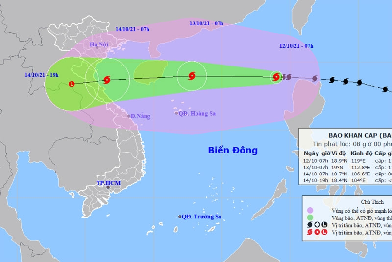
The National Center for Hydro-Meteorological Forecasting (NCHMF) reported storm Kompasu entered Vietnam's waters in the late night of October 12 and would barrel toward the north-central region and coastal localities tomorrow.
At 7:00 pm on Tuesday, the storm lay 490 kilometers east-northeast of the Hoang Sa (Paracel) Islands in the East Sea (known internationally as the South China Sea) with winds of 90-120 kilometers per hour (kph).
In the next 12 hours, it is likely to move west at the speed of 25-30 kph and grow stronger. By 7:00 am on Thursday, the storm is predicted to lay off provinces from Thanh Hoa to Quang Binh with winds of 75 kph, according to the NCHMF.
It added that in the next 24 to 48 hours, the storm will move rapidly mainly to the west, traveling 25-30 kph, and is likely to gradually weaken in intensity. The strongest winds near its eye will be 60-75 kph.
A map on the route of storm Kompasu. Photo: NCHMF |
“Storm Kompasu is the eighth one to enter Vietnam's waters so far this year. It will move very fast and has a high probability of directly affecting the south of the northern delta and the central provinces from Thanh Hoa to Thua Thien Hue between October 13 and 15," Nguyen Van Huong, head of the center's climate forecasting department under the NCHMF, told The Hanoi Times.
All vessels operating in the danger zone are at high risk of being affected by strong winds, high waves, and tornadoes. Due to the circulation of the storm in combination with a cold spell, heavy rains will occur, resulting in possible floods on rivers in provinces along the central strip, from Thanh Hoa to Quang Binh, Huong noted.
Explaining the reason why there were three storms and tropical depressions formed in the East Sea within the past ten days, Huong said an intertropical convergence zone has been crossing the central region, which is the cradle of storm formation.
“Moreover, October is normally the time when most storms are formed in the East Sea," Huong said.
He also predicts that after storm Kompasu, about four to six storms and tropical depressions will appear in the East Sea, and two or three of them are likely to affect Vietnam.
* The NCHMF forecast that due to the influence of the tropical convergence zone and the strong southwest monsoon, the Central Highlands and the Southern region will face heavy rain and thunderstorms, even very heavy rain in some places in the afternoon and evening.


