Hanoi eyes bigger roles for rivers and lakes in 2021-2030 development plan
The plan includes revitalizing urban rivers, protecting lakes and waterways, and utilizing their scenic assets to create unique ecological spaces.
Hanoi has a distinctive geography, with its dense network of rivers and lakes averaging 0.5 to 1.0 km per square kilometer. This feature is a key development driver in the capital's master plan for 2021-2030, with a vision for 2050.
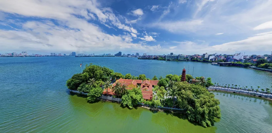
| West Lake holds significant cultural value as portrayed in numerous historical texts and poetic literature. Photo: Tran Anh/The Hanoi Times |
In particular, two major rivers flow through Hanoi: the Red River and the Da River. These are the largest rivers in northern Vietnam, hold significant socio-economic value, and are deeply intertwined with the region's thousand-year history, culture, and the connection between Thang Long and Xu Doai - an ancient cultural region to the West of Hanoi.
Historian Duong Trung Quoc noted; “In the traditional Vietnamese concept of feng shui, the Red River is seen as a lifeline for the people, but the Da River, along with Tan Mountain and the ancestral land across the Da River, holds spiritual significance. Additionally, the urban river system, especially the To Lich River, has been closely tied to the history of Thang Long - Hanoi.”
Apart from rivers, Hanoi boasts a diverse system of lakes, including about 115 urban lakes and 12 large suburban lakes (over 5 hectares, excluding ponds). Some lakes, such as West Lake, Hoan Kiem Lake, and Truc Bach Lake with remarkable cultural significance, are frequently mentioned in historical records and literature.
Several cultural spaces around these lakes, like those at West Lake and Hoan Kiem Lake, are effectively utilized. Many lakes also play crucial roles in urban landscape aesthetics, water regulation, and water supply for agriculture and aquaculture.
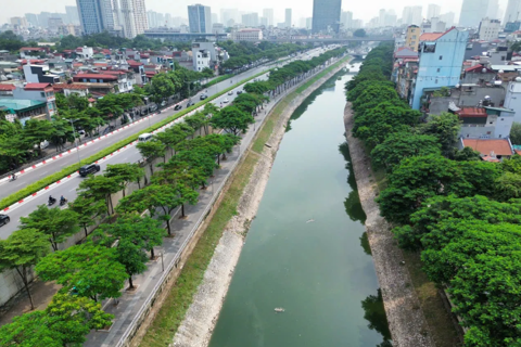
However, urbanization and population pressure have led to the degradation and pollution of many rivers and lakes in Hanoi. Some lakes have been encroached upon and filled for construction. The dumping of waste and wastewater directly into rivers and lakes has caused severe pollution. Many lakes suffer from sedimentation due to natural siltation and the absence of regular dredging. Water resource exploitation and economic development around these lakes have not been strictly regulated.
Sections of rivers running through urban areas and densely populated or industrial zones, like To Lich, Kim Nguu, Lu, Set, Nhue, and Day rivers, are heavily polluted. Recognizing the importance of Hanoi's rivers and lakes, the master plan emphasizes their role in urban, environmental, and landscape breakthroughs, aiming to harness their unique environmental and scenic values for the city's development.
| Red River from above. Photo: Pham Hung/The Hanoi Times |

Preserving and promoting distinctive ecological spaces
Given the significance of Hanoi’s lake and river systems, the planning includes the revitalization of urban rivers, the strict protection of lakes and water spaces, and the use of the scenic advantages of the river and lake systems to create distinctive ecological spaces. This includes maximizing the potential of West Lake, the Red River, the Duong River, and the To Lich River, identified as a top priority in the master plan.
Of particular note is the focus on the Red River as emphasized in Conclusion No.80-KL/TW: “Develop the Red River axis to make it a central development area for the capital, harmonizing ecological, cultural, historical, green, and modern urban spaces along its banks, contributing to a new identity for the civilized and modern Hanoi.” It also recommends the effective use of land along the Red and Duong rivers for economic and social development, especially in tourism and services.
The exploitation and enhancement of Hanoi's river and lake systems are detailed in the development plans for various sectors, especially cultural industries and tourism. This includes developing tourism corridors along rivers like the Red and To Lich rivers and creating new cultural parks and recreational spaces linked to these waterways.
Hanoi's master plan also aims to revive its historic waterway transportation, which has been underutilized in recent years despite its geographical advantages. Waterway transport is seen as a distinctive and crucial mode of freight and passenger transport, particularly for tourists, linking the capital region with the Red River Delta and the northern midland and mountainous areas via major rivers.
Furthermore, the master plan emphasizes the need to secure water resources, store, regulate, and distribute water resources equitably and efficiently to meet diverse needs. Sustainable and efficient use of water resources from the river and lake systems is critical for economic and social development, urban landscapes, national defense, and environmental protection.
| Research indicates that tapping the potential of Hanoi's river and lake systems will help preserve and enhance the city's cultural heritage through cultural spaces centered around these waterways, such as the Red River cultural space, West Lake, and Hoan Kiem Lake. This will also contribute to the development of urban economic spaces, landscapes, public spaces, and especially green spaces. Additionally, the river and lake systems will improve the drainage system and mitigate flooding in the urban areas of the capital. |
*Dr. Le Ngoc Anh is the director of the Hanoi Institute for Socio-Economic Development Studies