
Red River - a centerpiece in Hanoi’s green development
The vision is for Hanoi to become a vibrant, green, and serene metropolis with the Red River landscape axis.
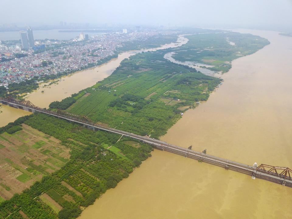
"For a long time, people often say that Hanoi has turned its back on the Red River," Nguyen Van Loc, a 60-year-old resident of Phuc Tan Ward, Hoan Kiem District, told The Hanoi Times as he gazed out at the vast expanse of lush green land ahead, with thriving banana plantations growing on the fertile alluvial plains known as the Red River Alluvial Island (or Bai giua song Hong in Vietnamese).
| The Middle Island of the Red River. Photo: Chien Cong/The Hanoi Times |

Spanning around 18 hectares and stretching 3.8 kilometers in length, the area is under the jurisdiction of Chuong Duong and Phuc Tan wards, Hoan Kiem District. For many years, a significant portion of the alluvial island has been tilled by over 30 households for vegetable production. However, there is still a portion of the land that remains vacant and covered with overgrown reeds.
"It is disheartening to see this land lying fallow while people struggle to find decent housing in Hanoi," said Loc.
With the announcement of the Red River Zoning Plan last March, Loc, who grew up here all his life, expected to see the alluvial island transformed, just as he had seen development in other parts of Hanoi.
The plan, drawn at a scale of 1:5,000, covers an area of nearly 11,000 hectares from both banks of the Red River in 55 wards of 13 districts.
Furthermore, the plan aims to revitalize and upgrade existing residential areas, preserve historical monuments and architecturally significant structures, and use available land for new development, thereby creating a refreshed urban environment on both sides of the Red River, Tuan said.
Luu Quang Huy, director of the Hanoi Urban Planning Institute, the agency responsible for drafting the master plan, noted that such a vision had changed Hanoi's development direction from "turning back" to "facing" the Red River.
Huy's view was echoed by Prof. Nguyen Quang Ngoc, Deputy Chairman of the Vietnam Historical Association, who stressed the crucial role of the Red River in shaping the capital and driving change in the deltaic region in terms of history, economy, and social and cultural development.
"This is particularly important for Hanoi, which is central to the Red River Delta," Ngoc said.
Given the renewed attractiveness of the Red River region, Hanoi is currently undergoing rapid urbanization on both sides of the river banks. In addition to the existing bridge and road infrastructure, a number of new and modern bridges have been built, complemented by ongoing projects such as Ring Road 2, Ring Road 3, Ring Road 3.5, and especially Ring Road 4 - the Hanoi Capital Region.
"The improved transportation network connecting both sides of the river, as well as the city center and surrounding areas, has contributed to the revitalization of the Red River as a central development axis for Hanoi," said Ngoc.
| The Middle Island is set to feature a network of spacious parks and gardens for the public. Photo: Hai Linh/The Hanoi Times |
While such a plan fits with Hanoi's goal of building a modern and green city, the authorities are also planning to develop districts along the Red River, including Dong Anh and Gia Lam on the left bank, and Dan Phuong, Hoai Duc, and Thanh Tri on the right bank. To the south of the Red River, the district of Van Giang in the northern province of Hung Yen is also experiencing significant growth and is expected to be developed into a city in the future.
Architect Tran Ngoc Chinh, chairman of the Vietnam Urban Development Planning Association, emphasized the importance of the Red River, which extends beyond Hanoi and encompasses the vast delta region.
"Realizing the potential of the Red River as a prominent landscape axis for the capital is urgent," said Chinh.
As the Red River Zoning Plan is seen as a game changer for the region, Chinh emphasized that the realization of this plan requires active and robust participation from the local government and relevant ministries and departments to resolve all outstanding issues.
Prioritizing the preservation of nature
Nguyen Dinh Duong, the former director of the Hanoi Institute for Socio-Economic Development, endorsed Hanoi's policy of identifying the Red River as the main axis for development.
He noted that planning should include the entire 163-kilometer stretch of the river, which extends beyond Hanoi's central urban area. "Water security, both for residents of the capital and the Red River Delta, should be a focal point," Duong said.
Duong urged Hanoi to work with upstream provinces to find solutions that ensure stable water flows, secure flood drainage corridors, and promote sustainable development.
"At the same time, upstream provinces must commit to preventing wastewater discharge into the Red River from burdening downstream provinces, including Hanoi," he said.
According to architect Dao Ngoc Nghiem, vice chairman of the Vietnam Association for Urban Planning and Development, extensive studies of the Red River have been conducted over the years by both domestic and foreign experts.
In addition to the economic aspects, Nghiem suggested that full attention be given to exploring the cultural and historical values of the river. It is crucial to identify and preserve the remaining cultural heritage on both sides of the river. Hanoi should also use science and technology to provide stability and enhance citizens' quality of life.
For sustainable riverbank development, architect Pham Thi Nham, deputy director of the Vietnam Institute of Urban and Rural Planning, stressed the need to prioritize preserving naturalness and following the course of the Red River.
"Excessive concrete construction should be avoided, and the burden of infrastructure on both sides of the river should be a minimum. Instead, a network of spacious parks and gardens should be built in the areas along the river, with easy access for the public to enjoy and relax," Nham said.


![[Hanoi thriving] Dream of a riverside city](https://cdn-media.hanoitimes.vn/2022/05/14/cover_01.jpg?w=480&h=320&q=100)


