Typhoon Kalmaegi moves faster to central Vietnam, causing extreme risk level
The storm is forecast to keep moving west-northwest, make landfall by 7 AM on November 7 and weaken into a tropical depression.
THE HANOI TIMES — Typhoon Kalmaegi has maintained its direction towards central Vietnam and intensified at around 30 kilometers per hour (kph), causing natural disaster risk level 4 (red) in the five-level category.
According to the National Center for Hydro-Meteorological Forecasting (NCHMF), by 7 PM on November 6, Kalmaegi is forecast to be over coastal areas between Quang Ngai and Dak Lak provinces, sustaining maximum winds of level 13-14 at 25kph.
The disaster risk level 4 is assessed for the western central East Sea and inland areas east of Quang Ngai to Gia Lai provinces.

Satellite image of Typhoon Kalmaegi at 11 AM on November 6. Source: The National Center for Hydro-Meteorological Forecasting
By 7 AM on November 7, the storm is expected to make landfall and weaken into a tropical depression over southern Laos, with winds descending.
Over the East Sea, the central region will experience strong winds of level 8-11, increasing to 12-14 near the storm’s core, with gusts up to level 17. Waves will reach up to 8-10 meters, causing very rough seas.
Along the sea areas from southern Quang Tri to Dak Lak provinces, sea levels may rise by 0.4m-0.8m, posing risks of flooding in low-lying zones, seawater overtopping dykes, coastal erosion and delayed flood drainage.
All vessels and aquaculture operations within the danger zone will be heavily affected by thunderstorms, whirlwinds, strong winds and high waves.
Under the impact of Typhoon Kalmaegi, extremely heavy rain is forecast for regions from Danang city to Dak Lak Province on November 6 and 7, with rainfall ranging from 200m-400mm, and some areas exceeding 600mm.
From central province of Quang Tri to central highland of Lam Dong, rainfall will range from 150mm-300 mm, with certain areas exceeding 450mm.
The NCHMF warned of a high risk of extreme rainfall exceeding 200mm, whirlwinds, and strong gusts before and during the storm’s landfall, particularly in areas between Danang city and Khanh Hoa Province.
Downpour is expected to ease from November 8, though provinces of Quang Tri to Thanh Hoa will see moderate to heavy rain of 50mm-150mm, with some areas possibly exceeding 200mm.

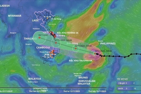
A map released at 2 PM on November 6 traces the direction of Typhoon Kalmaegi. Source: The National Center for Hydro-Meteorological Forecasting
Mai Van Khiem, Director of the NCHMF said that Kalmaegi is a strong and fast-moving storm with a broad circulation, with a track and pattern of influence similar to Typhoon Damrey (2017) and Typhoon Molave (2020), but differs in wind intensity and higher rainfall.
“Compared to the previous storms, Kalmaegi is predicted to cause more localized heavy rainfall than Damrey and Molave, but will likely not result in major flooding as experienced after storm Fengshen, the 12th in the East Sea this year,” Khiem noted.
In response to Kalmaegi’s complex evolution, some central areas have issued a ban on all fishing and marine activities from 6 AM on November 5, while ordered schools in coastal communes to close from November 5 to November 7.