Water levels in Red River drop to safe mark
From now until the weekend, water levels in Hanoi's main river are expected to drop significantly.
Water levels in the lower Red River will continue to slowly fall below the alert level 1 in two days, according to the National Hydro-Meteorological Forecasting Center.
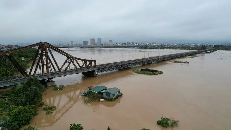
| Long Bien Bridge is closed to traffic on September 11. Photo: The Hanoi Times |
The agency predicted that the river level in Hanoi could fall to 8.9 meters - below the level 1 alert - on Saturday morning (September 14), as rainfall tapers off and drainage continues.
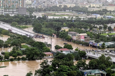
The river crested at 11.30 meters at 14:00 today (September 12), 0.2 meters below the alert level 3. This was the highest water level since the water level surpassed the 11-meter mark in 2004 (11.04m). It later dropped to 11.16 meters, below the alert level 3.
Phung Tien Dung, in charge of the center's hydrological forecast, predicted that the downstream water level of the Red River would continue to fall slowly to 8.9 meters on Saturday, 0.6 meters below the alert level 1.
At a press conference on September 11, the Center's Director Mai Van Khiem said that rainfall in most mountainous and midland areas of northern Vietnam has decreased over the past two days.
He predicted that the rains will be concentrated in the Red River Delta and the northeastern and north-central regions, and will begin to subside after today.
Khiem also noted that many reservoirs, including Thac Ba, had reached full capacity due to several days of heavy rainfall, but that inflows were down compared to two days ago. "The pressure has temporarily eased. However, we must continue to monitor the changes in rainfall patterns in the central and mountainous areas," he said.
Vu Duc Long, in charge of weather forecast management at the Meteorological and Hydrological Administration, said warnings of urban flooding in Hanoi would be issued in the event of heavy rain.
"Every time there is a big rain, the city is often flooded. But it's inaccurate to say that the inner districts could be submerged if the water level of the Red River rises," he said, as quoted by the Vietnam News Agency.
He explained that the recent rise in the river's water level could only flood the riparian areas such as Phuc Tan, Phuc Xa, and Bach Dang districts.
"We want to make it clear to the public that the rising water of the Red River will not flood the entire downtown area," Long said.
He also warned that harsh weather conditions and possible heavy rains could keep outlying areas underwater for another two or three days.
At the press conference, Vo Van Hoa, Director of the Hydrological and Meteorological Station for the Northern Midlands and Delta, warned that the risk of flooding could continue for the next few days.
In Hanoi, the possibility of flooding depends heavily on future rainfall and the operation of upstream hydroelectric reservoirs, he said.
According to Hoa, urban flooding will occur in the riparian areas of Tay Ho, Ba Dinh, Hoan Kiem, and Long Bien districts, while rural districts such as Chuong My, Ung Hoa, Thanh Tri, Hoai Duc, Phuc Tho, Son Tay, Dong Anh and Ha Dong will continue to be submerged due to rising water levels in smaller rivers.
"The biggest risk we currently see is prolonged flooding in some districts like Chuong My due to high water levels in major rivers and slow drainage," he predicted.
Waterway, bridge traffic restricted
On September 11, the Hanoi Department of Transportation issued a ban on vessels navigating the Day and Ca Lo Rivers, Yen Stream, and Suoi Hai Lake.
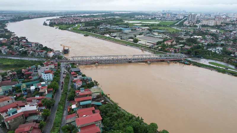
| The water level of the Red River at the Duong Bridge. Photo: The Hanoi Times |
The ban aims to ensure the safety of waterways as northern provinces and cities continue to experience heavy rains, causing hydropower plants to release water and river levels in Hanoi to rise, the department said.
The Department has ordered the Traffic Inspectorate and Rescue Services to be on duty around the clock to ensure safety on local waterways. The ban will remain in effect until further notice.
It has also asked Hanoi Traffic Police to cooperate in regularly monitoring traffic conditions on local waterways to ensure safety and prevent traffic jams during flooding.
In addition, the department plans to inspect more than 500 bridges in Hanoi for repairs and upgrades to prevent collapses. Of the nine bridges spanning the Red River, the Long Bien and Chuong Duong bridges are considered the oldest and weakest.
"The ongoing flooding requires urgent measures to protect and reinforce these two bridges to ensure public safety," said Hanoi's Disaster Prevention and Search and Rescue Command.
In an interview with Tien Phong (Vanguard) newspaper, Tran Huu Bao, Deputy Director of the Hanoi Department of Transportation, said that passenger buses and trucks weighing more than 0.5 tons have been banned from the Chuong Duong Bridge since September 10.
Bao also said that recent inspections show that the Chuong Duong Bridge remains structurally sound and safe for use.
He could not comment on the Long Bien Bridge, which is under the jurisdiction of the Vietnam Railways Corporation and the Ministry of Transport.
To ensure the safety of road traffic on the Long Bien Bridge during rising floodwaters, the city authorities and the Vietnam Railways Corporation agreed to close the bridge to traffic starting at 3 p.m. on September 10.