Hanoi urges to accelerate zoning plan for Red river
Developments along the Red river will play an important role in driving Hanoi's future.
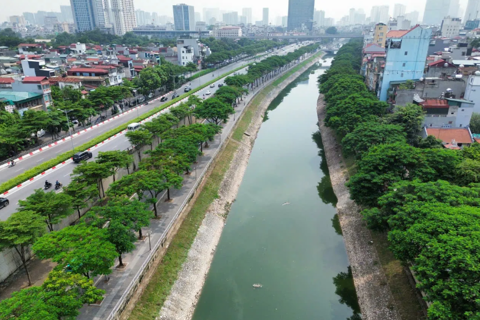
Hanoi needs to remove obstacles to accelerate the zoning plan of the riparian areas on both sides of the Red river that runs through the city, Secretary of the municipal Party Committee Vuong Dinh Hue said at a meeting last week.
Hue said that Hanoi needs to complete the zoning plans, including the plan on both sides of the Red river and making full use of the land resources in the riparian areas along the river banks.
As the zoning plan has not been devised, land resources in Hanoi have not been made full use of. No one wants to make long-term investments in the riparian areas as winning bidders are only entitled to the land usufruct for five years.
Hue emphasized that planning the Red river will make resources in terms of land, landscape and environment to become fulcrum for the capital city's development.
Secretary of the municipal Party Committee Vuong Dinh Hue speaks at the meeting on February 25. Photo: Thanh Hai |

"The riparian areas in Dan Phuong and Hoai Duc districts are immense but left fallow. There is a large riparian area in Hoan Kiem district which has been left unused because of the lack of a zoning plan," Hue said.
Under the futuristic zoning plan, the riparian areas will become ecological urban areas. About 900,000 local residents along both sides of the river will be able to make a living when the plan is carried out.
In action
In order to remove obstacles for the zoning plan, Secretary of the municipal Party Committee Vuong Dinh Hue had a working session with the Ministry of Agriculture and Rural Development on July, 2020.
Currently, the city is actively working with the Ministry of Agriculture and Rural Development to map out the anti-flood plan and submit it to the National Assembly and the prime minister.
In recent years, Hanoi has prepared infrastructure for the eventual urban development in the riparian areas by building bridges crossing the Red river.
Most recently, the Hanoi Department of Planning and Architecture has made public the architecture plan of Tu Lien bridge, connecting Dong Anh district and Tay Ho district.
The municipal government is also considering two options of either to build Tran Hung Dao bridge or a tunnel crossing the Red river to link Hoan Kiem and Long Bien districts.
Making great progress
According to Vice Chairman of the Hanoi People's Committee Duong Duc Tuan, the Red River planning project is built based the study of the section of about 40 kilometers along the river, from Hong Ha bridge to Me So bridge. The plan will cover an area of about 11,000 hectares in 13 districts.
Tuan stressed that the completion of the 1:2000 scale zoning plan of the riparian areas on both sides of the Red river the section running through the city is a great progress after a long time of suspension pending.