Vietnam’s Gulf of Tonkin baseline helps protect sovereignty rights
The baseline, which determines the width of Vietnam’s territorial sea in the Gulf of Tonkin, is the legal basis for its maritime boundaries, in line with the United Nations Convention and the Vietnam-China delimitation agreement.
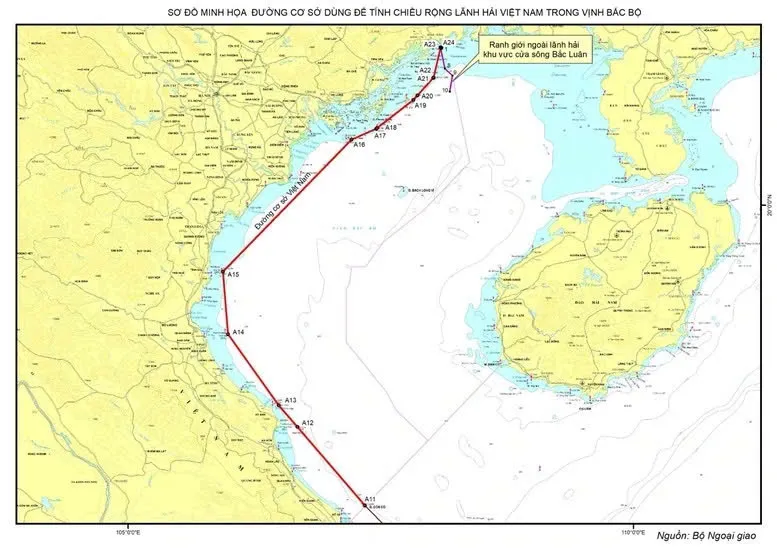
Vietnam has published a map that defines a 14-point baseline in the Gulf of Tonkin from the northern coast province of Quang Ninh to the central province of Quang Tri.
It marks the official completion of Vietnam’s baseline that extends from north to south, from the mouth of the Bac Luan River bordering China to Point 0 on the southwest boundary of the waters between Vietnam and Cambodia.
The baseline “creates an additional legal foundation to safeguard and uphold Vietnam’s sovereignty, sovereign rights, and jurisdiction, support economic growth, enhance maritime management, and foster international cooperation in the future,” according to the announcement on February 21 by the Ministry of Foreign Affairs.
A baseline, as defined by the United Nations Convention on the Law of the Sea (UNCLOS), is the line (or curve) along the coast from which the seaward limits of a state’s territorial sea and certain other maritime zones of jurisdiction are measured, such as a state’s exclusive economic zone. Normally, a sea baseline follows the low-water line of a coastal state. When the coast is deeply indented, has fringing islands or is highly unstable, straight baselines may be used.
| The map defining baseline in the Gulf of Tonkin released by the Ministry of Foreign Affairs. Photo: MOFA |
The necessity of baseline in the Gulf of Tonkin
The baseline used to determine the width of Vietnam’s territorial sea in the Gulf of Tonkin is the legal basis for the delimitation of Vietnam’s maritime zones, in accordance with the UNCLOS and the Vietnam-China Agreement on the Delimitation in the Gulf of Tonkin in 2000.
It becomes essential as the Vietnamese Government’s Declaration on November 12, 1982, defined the baseline only from the historical waters between Vietnam and Cambodia in the south to Con Co Island in the central region. At that time, the Gulf of Tonkin was considered historical waters under Vietnam’s internal waters regime, and no baseline had been established within the Gulf.
However, on December 25, 2000, Vietnam and China signed an agreement on the delimitation of their territorial seas, exclusive economic zones (EEZ), and continental shelves in the Gulf of Tonkin. Both countries recognized the gulf as comprising all maritime zones, including internal waters, territorial sea, contiguous zone, exclusive economic zone, and continental shelf under UNCLOS 1982.
Following the agreement’s enforcement in 2004, the Gulf of Tonkin was no longer regarded as historical waters under Vietnam’s internal waters regime, as previously defined in the 1982 Government Declaration.
As a result, it became necessary for Vietnam to establish a baseline in the Gulf of Tonkin to determine the outer limits of its maritime zones in the region and provide a clear legal basis for its maritime activities.
The baseline exercises Vietnam’s sovereign rights as a coastal state in line with the UNCLOS 1982, to which Vietnam is a signatory.
The move also complies with Vietnamese law, as stipulated in Article 8 of the Law of the Sea of Vietnam: “The government shall determine and announce the baseline in areas where it has not yet been established, after receiving approval from the National Assembly.”
Scope of Vietnam’s baseline in the Gulf of Tonkin
The baseline system in the Gulf of Tonkin consists of two parts, including the Straight Baseline System and the Normal Baseline.
The Straight Baseline System starts from point A11 on Con Co Island and runs through base points along the coasts of 10 Vietnamese coastal provinces and cities: Quang Ninh, Haiphong, Thai Binh, Nam Dinh, Ninh Binh, Thanh Hoa, Nghe An, Ha Tinh, Quang Binh, and Quang Tri.
While the Normal Baseline surrounds Bach Long Vi Island.
The baseline used to determine the width of the territorial sea around Bach Long Vi Island follows the normal baseline method, based on the lowest low-water line along the island’s coastline. The outer boundary of the territorial sea at the Bac Luan River estuary is determined by connecting nine points according to the demarcation line agreed upon between Vietnam and China in the Gulf of Tonkin.
The Gulf of Tonkin is a semi-enclosed sea with many divided areas and regions characterized by unstable geological conditions and seasonal changes. In this gulf, Vietnam’s Ha Long Bay area, featuring 1,969 islands, creates a particularly complex geographical landscape.
The waters within Ha Long Bay and the coastal islands of the Gulf of Tonkin are closely interconnected, qualifying them as Vietnam’s internal waters, meeting the criteria set out in Article 7 of the UNCLOS for the drawing of straight baselines to determine the width of the territorial sea.
The Gulf of Tonkin, bordered by the coastlines of Vietnam and China, is a vital maritime trade route in Southeast Asia and a mineral-rich region rich with significant strategic importance to national security and defense.