Park on Red River’s alluvial islet to serve as Hanoi’s tourism hotspot
The goal of building the Red River as a central landscape axis is to create an open, green space integrated with modern and well-planned urban infrastructure, transforming it into an appealing tourist destination.
Hanoi’s plan to turn the alluvial islet on the Red River into a cultural park not only helps the city maximize the utilization of land resources but also leverages the inherent advantages and natural beauty of the Red River.
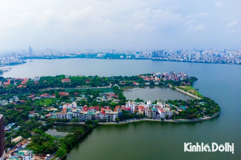
| The Red River's alluvial islet. Photo: Khanh Huy/The Hanoi Times |
Earlier, the city People's Committee approved four districts - Hoan Kiem, Long Bien, Ba Dinh, and Tay Ho - to conduct a comprehensive study on transforming the alluvial islet along the Red River from Thang Long Bridge to Thanh Tri Bridge into a multi-purpose cultural park.
Pham Quoc Tuyen, deputy director of Hanoi's Department of Planning and Architecture, said the initiative is in line with the Red River Zoning Plan, which envisions transforming the region into lush green spaces, agricultural areas, and attractive tourist attractions to promote economic activities centered on tourism.
"The main principle guiding the development is the restoration of natural parks, urban green spaces, and public areas to meet the needs of the population," he said.
Over the years, alluvium has accumulated in the middle of the Red River, creating a large expanse of land. This area has been left unused, with dozens of hectares abandoned, leading to the growth of weeds and some parts being illegally occupied for farming.
The limited availability of land in Hanoi, coupled with the lack of recreational areas, has led to the emergence of entertainment areas on the islet, posing potential safety risks and environmental pollution.
Tuyen said the project aims to effectively utilize this land resource while capitalizing on the Red River's inherent advantages and natural landscape.
"By using the Red River as a central landscape axis, the goal is to create an open, green space integrated with modern and well-planned urban infrastructure, transforming it into an attractive tourist destination," he said.
This development will attract residents and tourists from other provinces when they visit the capital".
In particular, the Red River's alluvial islet will be divided into a functional area for agro-tourism and landscaping. Households currently living in the area will be allowed to continue growing short-term crops, while appropriate schemes will be drawn up to transform these areas as part of the overall development plan.
The park will have designated areas for creative activities, playgrounds, lawns interspersed with existing perennial plants, recreational and sports areas (such as grass skating rinks) in keeping with the natural terrain, and areas for fishing, diving, and other activities.
The floodplain will be used to create functional green park areas, preserving existing large trees and incorporating areas for planting short-lived trees, ornamental plants, and seasonal flowers to enhance tourist attraction.
Untapped potential
Architects see great potential in developing the alluvial islet into a public space. However, district authorities are advised to approach this endeavor cautiously, conducting extensive consultations with experts, scientists, and the public to ensure effective land use while prioritizing safety measures to prevent erosion and ensure proper flood drainage.
These efforts should align with the Red River Urban Land Planning guidelines and the approved Hanoi Capital Construction Master Plan, which covers the period by 2030 with a vision of 2050.
Dr. Architect Le Thi Bich Thuan, Deputy Secretary General of the Vietnam Construction Association, highlights that the Red River bank area in Hoan Kiem District falls within the scope of the Red River Green Corridor according to the orientation of the Capital Construction Master Plan approved by the Prime Minister, reflecting an area designated for green and recreational purposes.
The plan is expected to benefit most of Hoan Kiem District, which has a high population density with about 150,000 people living, or about 35,000 people per square kilometer.
Apart from the water surface and green areas around Hoan Kiem Lake, which covers about 13.5 hectares and serves as a public, cultural, and spiritual space, the concentrated green spaces in Hoan Kiem District are mainly located at intersections. However, these spaces often take the form of "traffic islands" and small public flower gardens, which are insufficient to meet the needs of the urban population and do not adequately contribute to creating a suitable living environment for residents.
By taking advantage of the Red River, the alluvial islet has the potential to become a compelling tourist attraction, not only for residents of the district and the city but also for visitors from around the country. This addition would complement the existing open spaces of the Old Quarter and further enhance the appeal of Hanoi's historic district.