Hanoi to report on planning the Red river’s riparian areas: Party official
Solving the drainage problem in the development of the riparian areas has been the reason the land along the Red river remains unplanned.
Hanoi will report to the central government on the planning of the riparian areas on both sides of the Red river, ensuring that no land in Hanoi is left without being planned, Secretary of the Hanoi Party Committee Vuong Dinh Hue said at the recent meeting with voters in Dan Phuong district.
Hue said that the general zoning plan for the capital city until 2030, with vision to 2050 had been approved by the Prime Minister since 2011. However, the areas along the Red river have remained the loophole of the plan.
| Secretary of the Hanoi Party Committee Vuong Dinh Hue speaks at the meeting with Dan Phuong district’s voters. Photo: VGP |

So far, solving the drainage problem in the development of the riparian areas has been the reason the land along the Red river remains unplanned, Hue said.
Dan Phuong district’s land fund has about 1,200 ha of riparian areas. However, the current regulations have not allowed long-term investment in these areas in order to ensure flood prevention work.
On the application of high technology to the reclamation of riparian areas for farming, voter Do Van Dang, who lives in Trung Chau commune, suggested that the municipal government devise a mechanism to draw investment in irrigation in riparian areas.
Dang also asked Hanoi’s authorities to keep constructing Huu Hong (the right side of the Red river) dike section from Hong Ha commune to the end of Dan Phuong district.
In 2017, Chairman of the municipal People’s Committee Nguyen Duc Chung required some investors to devise planning schemes to develop the areas along the Red river which ensure the city’s flood-resistant capability and create a modern urban area along the river.
Hanoi's authorities requested the planning to be divided into two phases, with the first one covering the areas on the banks of the river from Thang Long bridge to Thanh Tri bridge and the second one covering the rest.
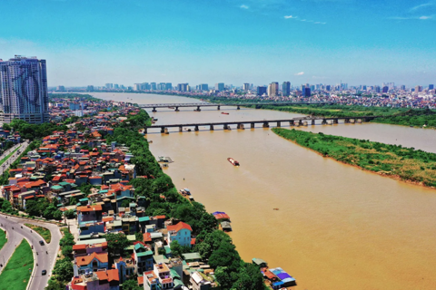
The Red river, originating in China, flows through Hanoi and several provinces in the north of Vietnam before emptying into the Gulf of Tonkin.
Apart from being one of the main river systems that plays a crucial role in irrigation and waterway traffic, the river is also considered to be a symbol of the capital city.